Map menu, version 3.0.1 Alpha
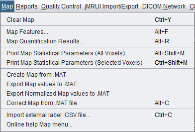
Version 3.0.1 Alpha Map menu screenshot.
 spectrIm-QMRS
Version 3.0.3 Alpha International
spectrIm-QMRS
Version 3.0.3 Alpha International
Current release: 3.0.3 alpha international for Windows and Linux. This guide retains earlier screenshots and version-specific descriptions. Their original version labels are preserved; appearance and window placement may differ in 3.0.3. See the release notes.
Clinical Viewer GUI
The Map menu creates and manages spatial overlays derived from MRS(I) signal features, quantification results, external files, and imported labels. It is used to turn voxel-wise spectral information into maps that can be inspected on the anatomical background image.
In spectrIm-QMRS, a map is a numeric value assigned to each MRSI voxel and displayed as a color overlay. Maps can represent simple spectral properties such as SNR, signal intensity, phase, noise, or statistical descriptors, but also fitted quantities such as metabolite amplitudes, TDFDFit quality numbers, temperature maps, or quality-control scores.
The old website correctly described the Map menu as the place where quantitation results and predefined map types are visualized. The version 3.0.1 Alpha menu is more focused on map creation, map statistics, MATLAB exchange, and external label overlays.
Version 3.0.1 Alpha Map menu screenshot.
Removes the current color map overlay from the viewer. This does not delete spectroscopy data, fitted results, or imported files; it only clears the currently displayed map state.
Opens the feature-map interface. This interface lets the user create maps from built-in spectral features. The current source includes feature functions such as FD peak SNR, FD magnitude sum, FD absorption sum, FD region ratios, phase, TD and FD noise, TD and FD mean, standard deviation, skewness, kurtosis, TD mean SNR, quality map, temperature, and TDFDFit quality number.
Some features require one or two user-defined spectral ranges. For example, a frequency-domain ratio map needs two frequency ranges, while SNR-like maps need a signal or noise interval. These ranges are selected in the map-feature dialog and should be checked against the acquisition and nucleus being reviewed.
Creates maps from available quantification results. For legacy workflows this can use jMRUI-style quantification results. When TDFDFit results are available, spectrIm-QMRS opens the TDFDFit results map interface using the available metabolites and feature names from the TDFDFit result store.
This command is central after fitting: it turns fitted amplitudes, frequency shifts, damping parameters, quality numbers, or other fitted features into spatial maps for review and reporting.
The version 3.0.1 Alpha dialog also includes interactive auto-scale clipping, so outlier voxels can be handled without changing the underlying fitted values. The dedicated guide describes how to launch the dialog, choose fitted quantities, clip outliers, mask excluded voxels, and apply Gaussian smoothing to the displayed map.
Prints statistical parameters for the current map using all voxels. The old website described this as a way to compute statistical values for the intersection between the spectroscopy volume and the background image. In the current v3 menu this item operates on the displayed map values.
Typical values include the number of voxels or pixels, minimum, maximum, mean, standard deviation, skewness, and kurtosis.
To be checked manually: confirm the exact printed fields for version 3.0.1 Alpha and whether image-pixel statistics are still included or only voxel map values are reported.
Prints statistical parameters only for the currently selected voxels. This is useful when a lesion, reference region, contralateral region, or manually selected ROI should be summarized separately from the rest of the grid.
The selected-voxel variant is particularly useful after MRSI voxel selection, because the same selected region can be used for fitting, reporting, and map statistics.
Creates a map from a MATLAB .mat file. This allows
externally computed voxel-wise values to be brought back into
spectrIm-QMRS for visual inspection on the anatomical image and
MRSI grid.
To be checked manually: document the required variable names, matrix dimensions, and voxel ordering expected by the importer.
Saves the current map values to a MATLAB .mat file.
If the selected filename does not end in .mat, the
application appends the extension automatically.
Saves a normalized version of the current map values to a
MATLAB .mat file. This is intended for workflows
where absolute map values are less important than a normalized
spatial pattern or when maps must be compared across datasets.
To be checked manually: describe the normalization formula used
by saveMapToMAT(..., true).
Applies a correction template from a MATLAB .mat
file to the current map and updates the image panels. This can
support correction workflows where an externally generated
template or selection profile is used to adjust map values.
To be checked manually: document the required template format and intended correction use case.
Imports externally prepared label or overlay data from a CSV file. The Java code loads the CSV overlay label file and opens an overlay-selection frame where the user can choose how the imported columns should be interpreted and displayed.
This is useful when external segmentations, clinical labels, research annotations, or non-spectroscopic measurements need to be viewed in spatial relation to the MRSI grid.
To be checked manually: document the CSV header conventions, accepted column data types, and how imported labels are matched to voxels or image locations.
The previous website page mentioned auto-windowing, background MRI color scales, and image segmentation within selected spectroscopic regions. These functions are not visible in the version 3.0.1 Alpha Map menu screenshot.
To be checked manually: determine whether these functions moved to another menu, were removed, or should become a separate advanced image-overlay page.
The old Map help page referenced the common spectrIm and EU
project logos but did not include menu-specific screenshots.
The referenced legacy images have been copied into
assets/img/legacy/map for traceability.